Maps on climate impacts are now available in the GEOportal of the Minden-Lübbecke district.
Which places are affected by climate change and how? For this purpose, basic maps on the areas of heat, drought, river floods and heavy rain can now be viewed in the GEOportal of the district under the topic map “Climate Impacts”. The district of Minden-Lübbecke is one of eight regions in the evolving regions cooperation project. The project deals with adaptation to the consequences of climate change at regional and municipal level, which include increasing extreme weather events. An important building block in the project is this cartographic representation of climate impacts.
“I am glad that we as a district are involved in the Evolving Regions project – this helps us and our municipalities in many ways to position ourselves stably for the consequences of climate change, be it heavy rain, heat or drought. Many areas from agriculture and forestry, urban planning and civil protection benefit from the findings of the project, which we are already actively involved in today – because we can only find answers to a challenge like this together.”
District Administrator Anna Katharina Bölling
The project works with data that is available throughout NRW and can be used freely. In order to illustrate the climatic influences, for example, data from the German Weather Service (DWD) and the State Office for Nature, Environment and Consumer Protection of North Rhine-Westphalia (LANUV) as well as the Ministry of the Environment NRW and the Federal Office of Cartography and Geodesy (BKG) are used.
“Thanks to the dedicated work of the colleagues who supervise the Evolving Regions project at the Environment Agency and who work just as closely with the cadastral office for the GEOportal, we are now in a position to use the new data and findings for work within the district administration as well as in the entire district area in a variety of ways.”
Head of Department Lutz Freiberg
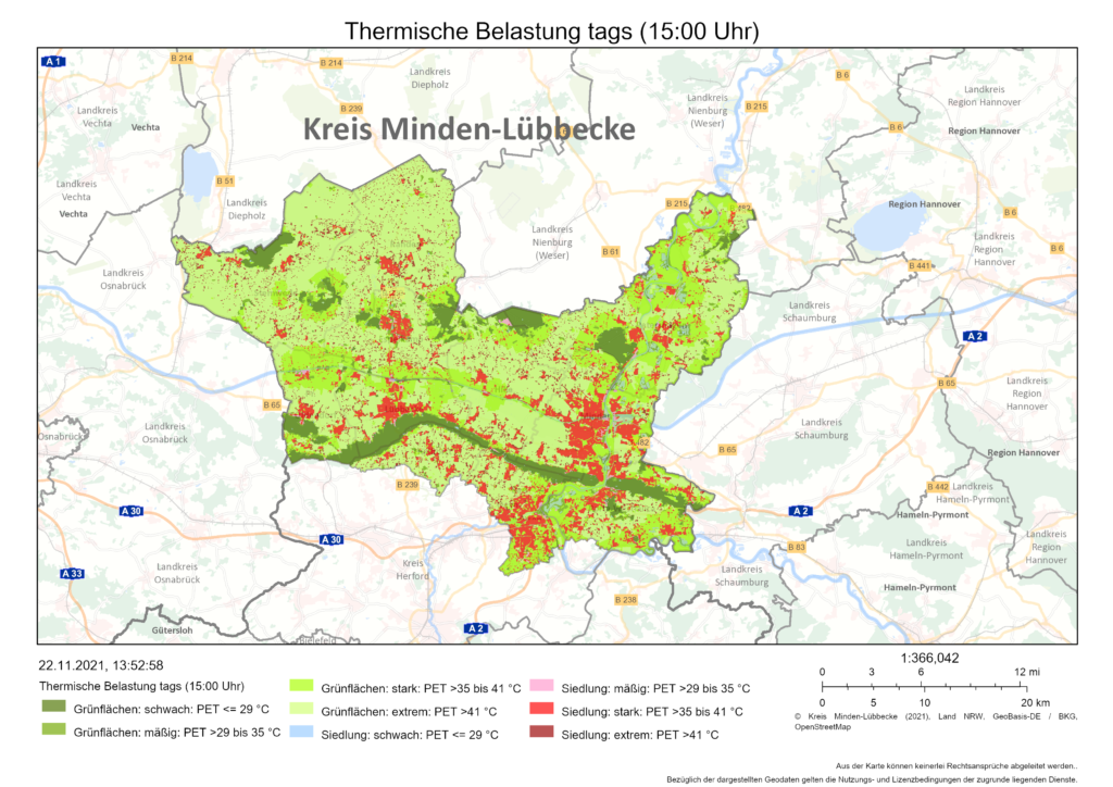
Where, for example, does the heat particularly strike in summer? – Interested citizens can use the CLIMATE modelling of the LANUV to see where there is a higher heat load in the district of Minden-Lübbecke. For example, the thermal load during the day (3 pm) for settlement and green areas is displayed. An example: In Minden’s city centre, on a typical summer day, a strong thermal load with PET values of >35 to 41 °C is achieved in many residential areas. The physiological equivalent temperature (PET) includes not only air temperature, but also humidity, wind and radiation, which affect human sensation.
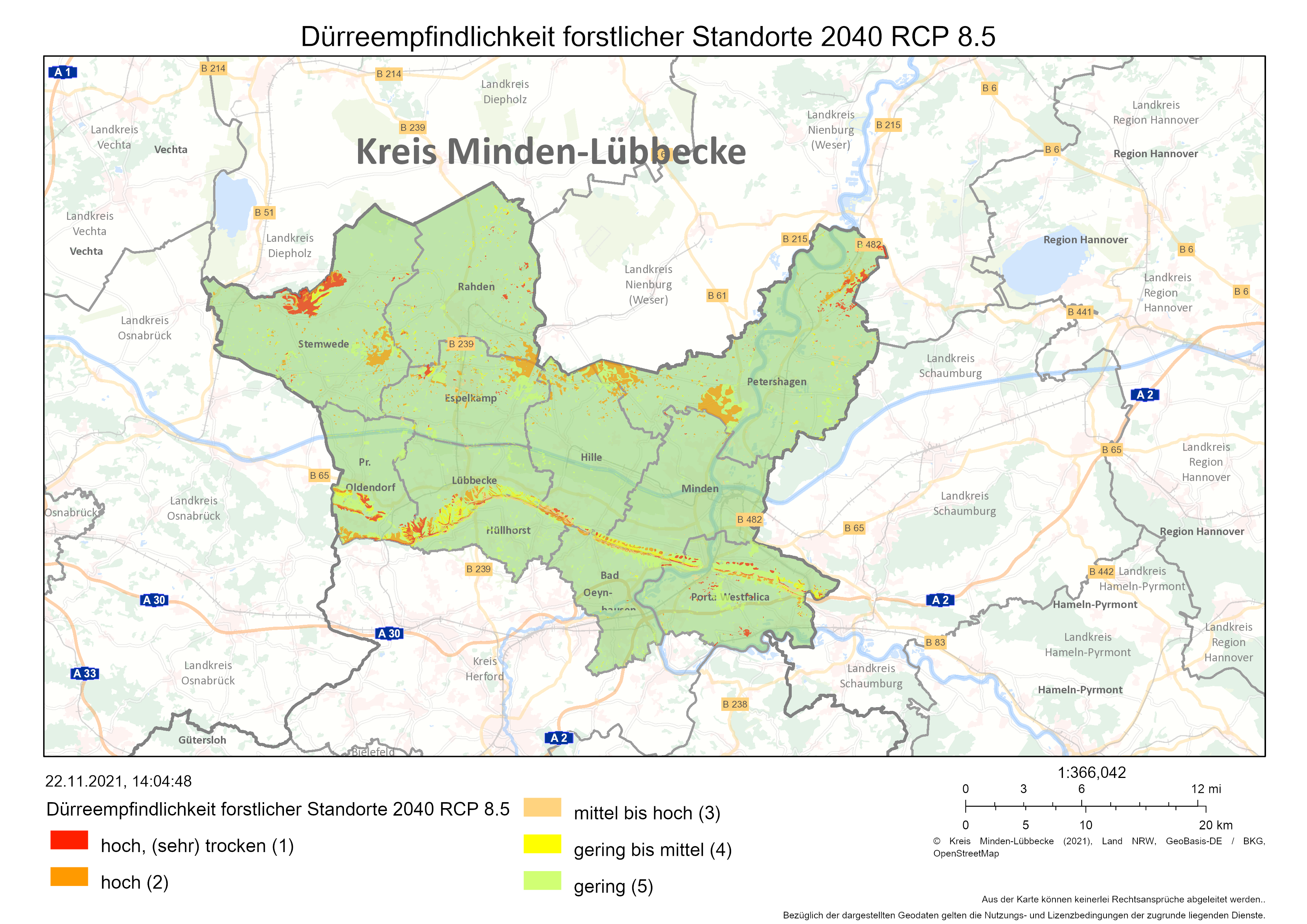
The drought sensitivity of forest sites can also be viewed on the maps. How affected are the forest sites in the district of Minden-Lübbecke already by the drought and how is the situation changing with climate change? This is shown here by a scenario analysis for the year 2040 in the event of a strong or moderate climate change.
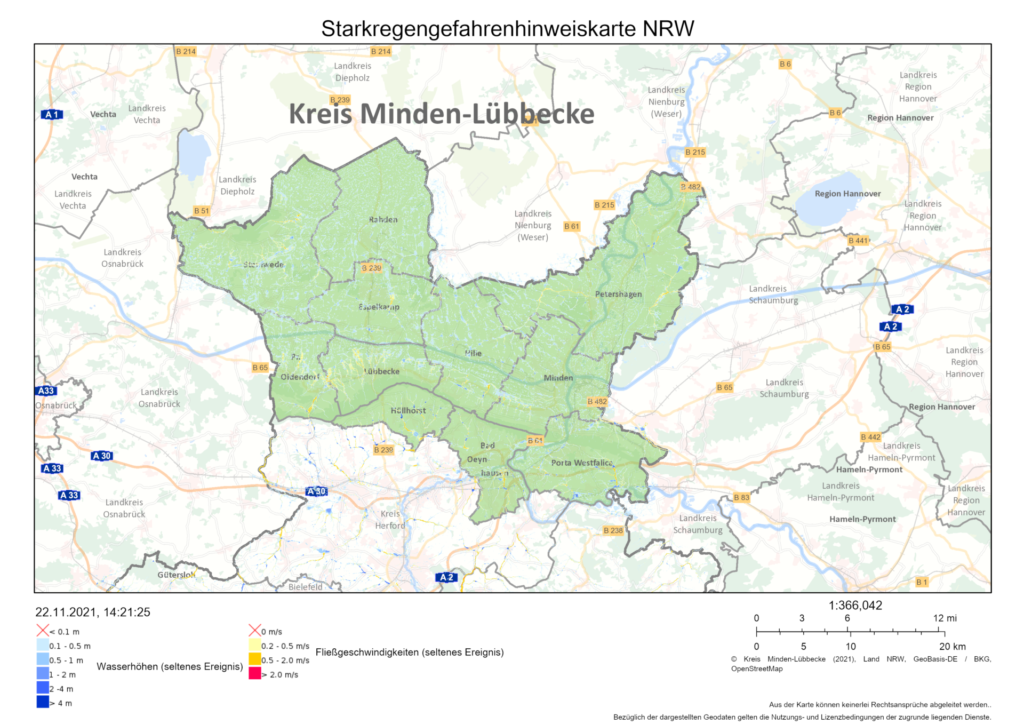
After the past hot summers, heavy rain events in particular were a major topic this year. Thus, the climate impact maps also deal with this aspect. The rise in temperature in the course of climate change means that the warm air can absorb more water, heavy precipitation increases. Heavy rain means: a lot of water in a short time, so it has a high intensity in relation to its duration and can therefore cause severe damage, even if there are no bodies of water nearby that could overflow the banks. In order to counteract such events, forward-looking planning is important. The heavy rain hazard warning map NRW shows in the GEOportal where special danger areas for flooding are located in the municipalities belonging to the district. The modelling published by the Federal Office of Cartography and Geodesy shows the flooded areas, water depths and flow velocities in the district of Minden-Lübbecke – and this for two species: for a rare, 100-yearly and for an extreme heavy rain event, assuming a duration of 60 minutes each. In addition, flood hazard maps have been available for floods on rivers for many years.
The flood hazard maps have been included in the work of civil protection and other areas of the district administration for some time now.
“For us, the additional heavy rain hazard maps are important data material in order to be able to plan protective measures for citizens in every single municipality in the district for this area as well.”
District Director Cornelia Schöder.
Her department includes civil protection and rescue services, and at the same time she is head of the crisis unit in the event of a major loss event. The maps are available to all cities and municipalities in order to be able to take the necessary precautions at the municipal level. The district is in close contact with all eleven municipalities.
The climate impact maps are available on the GEOportal of the Minden-Lübbecke district at: https://www.minden-luebbecke.de/Service/GEOportal/ (climate impact topic map). In the future, the project will intersperse the climatic foundations with spatial sensitivities (e.B residential population, buildings or social/technical infrastructures). In this way, the climate impact in the district becomes even clearer and better tailor-made measures for climate impact adaptation can be developed.
The press release of the district can be found here
Frontispiece: Drought sensitivity of forest sites 2040 – RCP 8.5 (Source: Landesbetrieb Wald und Holz NRW, Landesamt für Natur, Umwelt und Verbraucherschutz Nordrhein-Westfalen & Kreis Minden-Lübbecke 2021)